360 Degree Aerial Photography. Panoramic Future Views For Developers & Real Estate

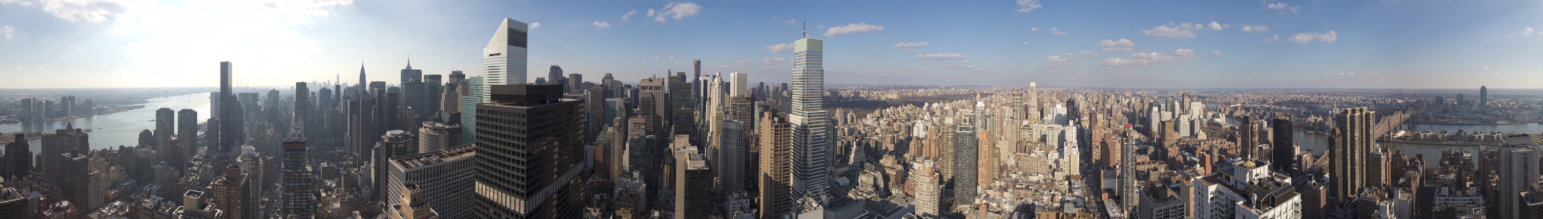
Learn About 360 Aerial Views

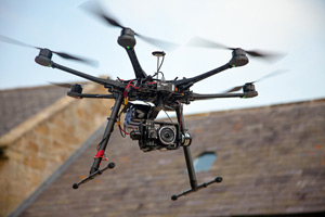
Please read over our Aerial 360 Views frequently asked questions below. There you can learn more about 360 aerial views that we offer. You will see that years of experience make all the difference. Panoramic aerial photography has never been easier thanks to drones. We are fully insured and we have a pilots license. If you are looking for a drone pilot and service to obtain Panoramic aerial photos for you please let us know. Contact us if you have any more questions. Thank you.

Aerial 360 Views

Please use the toggle switch to view answers to your aerial photography questions.

What are the drone safety considerations on the day of my flight?

Your drone flight will always be operated by an experienced and professional drone pilot with years of flight and camera experience. The drone is not large but certain safety precautions should be taken. Here are some tips for us all to help keep the panorama flight extra safe.

  • Don’t rush the shoot. If the weather is not right, we may need to reschedule.
  • Have the minimal amount of personnel on site.
  • Stand at least 20 feet away from the drone and never stand directly under it.
  • Do not use cell phones or other two-way communications during the drone flight session.
  • Please refrain from talking to other team members about non-flight related items while the drone is in operation.
  • Never walk up to and touch the rotor blades of the drone.
What about drone weather parameters? Is there a perfect flight day?

The perfect flight day is a term subject to interpretation which is something that we will agree on in advance. We like to fly our drones on sunny days although sometimes there are some clouds present, which is what we would call partly cloudy.

If a panoramic future view or development client is in a rush, we can really shoot on just about any day as long as the wind is not too high and there isn’t any precipitation. However, keep in mind that cloudy and overcast days typically remove any large shadows that may be present from the buildings around the future view.  This is something that we always consider as your drone panoramic photography end product is our ultimate consideration. Although, in production, we can find some clouds to add to the dynamic effect of the images.

Do the PanoDrone hexacopters run on batteries or gas?

All of PanoDrone’s hexacopters that are used for real estate development future views and 360 degree panoramas are energy efficient using clean green battery power. Further, we are aware that sometimes it may take longer to get that perfect panoramic view, so we always carry enough batteries to keep the drones flying and get your project done the way you want.

Is company representation necessary during the panoramic shoot?

Whether you need or want someone from your company present on the development, real estate or property while we do our drone shoot, is entirely up to you. However, if special site access is needed then we will obviously need access prior to or have a company representative available to us.

Keep in mind that you may want to add further input as far as specific panoramic needs or see the live footage during the photography/video session. We will do everything we can to obtain all future views information prior to the shoot.

How close can you fly to other buildings if in a crunch?

There’s not an exact number… however our UAV can fly in a way that provides adequate visual clearance from any objects. As the drone gets further away from the pilot the larger the spacing for safety. As long as there is visual clearance.

How do you know how high you are flying with the drone?

Our multicopters / drones have GPS and barometric altitude measuring sensors that displays relevant flight info on our monitor on the ground.  If we’re flying from the roof top of another building it’s helpful to know how tall that building is.

Do you provide a live view screen to see in real time?

Yes we can see what’s going on up there from our live ground monitor. Works off 5.8 ghz.

Do you also fly full sized manned helicopter for aerial photography?

Yes, we use a real manned helicopter for locations or altitudes not accessible by drone.

How long does it take you to prep the drone on site?

It takes about 10 minutes to prepare the PanoDrone for flight. Each flight is about five minutes and we then land to change batteries as needed to complete your shoot.

Do you offer in house photo editing?

Yes. By default on all panoramas we include photo editing and retouching. If you wish to have your team stitch the photos together this is also a possibility.

What about poor weather on the day of my shoot?

Weather and wind speed are critical as the drone needs to be able to maintain exact position in flight so the images line up properly to create a seamless 360. We will reschedule your aerial photo op for another day subject to weather and availability.

What amount of space do you need to land and take off for the drone? Other Factors?

About 20 ft x 20 ft flat surface is would be best with out dirt, dust or debris. Preferably away from any persons, construction, pedestrians and traffic.  Sometimes if a location has much debris sometimes we will try to fly from an adjacent site. If not we will utilize a large piece of flat rectangular wood, a large table provided or similar provided to us as a landing pad. If a location is excessively dusty we may need a local house down to prevent dust from flying into the camera sensor. This could effect the images. We don’t want that to happen.

Those are some pretty amazing panoramic photos on your website. I don’t understand the panoramic photo process please explain it to me.

Simply put we provide 360 degree panoramic photography by taking many photos in every direction from a single position in space and with computer editing and professional photo editors we stitch the photos together into a single seamless image that gives you amazing views in each direction. Weather and wind speed are critical as the drone needs to be able to maintain exact position in flight so the images line up properly.  Once completed these views can be used in print, in 3-D renderings or just about anywhere. It’s strength however is to display your Aerial Panoramas in their interactive flash form which is best used on your website. Our interactive Panos display wonderfully on a wide range of devices from PC to Mac, mobile phones, iphone, ipad and tablets.

What is an aerial 360 degree virtual tour?

360 degree aerial tours are simply special web based viewers created to work in your web browser specially to display 360 degree aerial imagery. If you visit the portfolio on our website you can view some 360 aerial virtual tours. These tours are simply to show people what it will look like from a building or condominium under development and still under construction.

How do I scroll around in the 360 degree aerial virtual tour?

Simply hold down the left click of your mouse and use the mouse to scroll around the 360. Lots of fun!

What are flattend 360 degree images?

Some of the beautiful city scape images on this website are what we call “flattened 360 images”. We provide these to our clients for each altitude we photograph so they can have greater flexibility to use 360’s in print, in 3d renderings ect. Here is a web quality example of a full 360 degree flattened image featured on our home page.  Your final product comes with all full 360 degree flattened images in full, medium and low resolution. As well as full 360 degree virtual tours for the web. Click image to view web quality 360 degree flat image.

360_2nd_ave_nyc

What information do we need to provide to hire the PanoDrone?

Thats a very good question. Clients should take into consideration that our drone measures altitude only in meters. All your dealings with us will be in meters. You can convert back to feet later as needed. We need to know the following from our clients.

  1. The exact location / GPS address.
  2. We need to know if the site is active construction zone or not.
  3. We need to know the condition of the lot. Does it contain dust and debris? Any workers present?
  4. Consider we measure zero meters in altitude from the take off point with our drone. If the location has a building on it already then we need to know the altitude of the roof of building in meters.
  5. We will also need safe roof access. We will fly right from the roof top if your property has a building on it.
  6. We need to know all the altitudes in meters you want us to perform panoramas for.
  7. Access. Are there any special considerations in order to access this property? Any safety issues?
  8. Timing. Give us an idea when you would like to have it done sometimes access plays a part with timing to enter a location.
What type of files do you provide as the final deliverables?

Each panorama we provide is custom edited from several normal camera images and then custom stitched together into a single 360 degree image. After that process is complete after about 14 +/- days after the shoot we then send out proofs to our client as a reduced resolution edited panorama for each elevation. When the time comes to download the final high resolution product we send links to download zip files that contain all the files needed to run the same pano-viewer on your computer or website. Those files need to be “unzipped” to be viewed with a free unzipping utility like winzip or some computers have that feature already built in. Inside the zip files you will find many files related to the interactive Panorama and may seen like gibberish at first but don’t move them around. Look for an .html file or web page document, open that up for each elevation and there you have your pano-viewer ready to be enjoyed and put online by your web person. If you look around you will also see a folder named “Flattend Panos” or similar, thats where you have a stand alone flat .jpg and/or .tiff image of each panorama at several different qualities. The highest quality flat image typically comes in at about 200-300 megabytes at a resolution of about 25,000 x 3200 +/- a few pixels. Thats large enough to make a spectacular print if you wanted to. (Thats more resolution than HD)

Just a few more options we also give our clients to consider

  • Each panorama notes the elevation in meters (default)
  • Compile each elevation panorama into its own interactive viewer for individual linking from your website. (default)
  • Optionally have us place a small google map of the location on a panorama. (default is no map)
  •  Optionally compile all elevations panoramas into a single web viewer with thumbnails for viewers to see all elevations.
Whats included when I hire PanoDrone?

You get the very best in customer service and support. We want to help your vision come true of obtaining amazing panoramic aerial photography for your property. This is what you get.

  • Free unlimited customer support
  • We carefully choose the best time and day based on weather
  • Friendly professional staff on site
  • Professional experienced pilot
  • Triple redundant safety check of the drone on the day of the flight
  • Quick and easy downloads of your final aerial 360 panoramas with in about 14 days
  • Optional expedited service
  • Our ever lasting gratitude. Thank you.
How long does it take to schedule a flight for my property?

Most of the year:

Based on the time of year and the work load the timing is typically 2-4 weeks. If you require an expedited service, please inquire.

Winter Months January and February:

In the north in the winter time rough weather conditions can cause a longer than normal wait time. We have experienced this in winter 2014.

Can you fly indoors and shoot 360 Panos?

Yes if there is enough room and light to safely fly we can do it!

What is a Drone?

panodroneA drone is a aircraft capable of some level of autonomous flight. There are many types of drones in the world.. some big some small. Our drone is compact, quiet and efficient, it runs on batteries. The only thing we shoot is aerial imagery that will leave viewers wanting more. Its a custom made drone designed for taking beautiful 360 degree panoramas hence the term PanoDrone. Typically developers and realtors use the aerial photos or “future views” of what the POV will look like from the different elevations on a new construction project. Some call this a “view study”. For example new condominium or an office building for example. Other times investors are testing the waters sort of say and they want to know .. to build or not to build based on the views alone. Sometimes they just want to know what floor will the prime views begin at so they are aware when to start charging a premium for the square footage.

What kind of weather do you fly in?

Typically for the sake of beautiful photos we like to fly on days when there are blue skies and a few scattered clouds. Some times its completely clear. The wind should be a maximum wind speed of 10-15 MPH and a maximum temperature of 90 degrees F in the summer. A minimum temperature of 40 degrees F in the winter.

What famous guy from the olden days said something cool about flight?

Flying-drones

“Once you have tasted flight, you will forever walk the earth with your eyes turned skyward, for there you have been, and there you will always long to return.”

Leonardo da Vinci

Can you fly at night?

We can fly from dawn to dusk. Typically we like to fly when the sun is mid sky. However special locations sometimes require other lighting considerations. Sometimes we are asked to perform dusk shots just when you can see the lights of the buildings in the city.

How much do you charge?

The cost varies on several factors.

  1. Location. We are based out of New York City and travel around the world as needed.
  2. Timing. How soon do you want it? vs. How soon do you need it really?
  3. Typically we can get you on our calender within 2-4 weeks. We deliver a finished product ready for download within about 14 days after.
  4. How many different altitudes / panoramas are needed for your project? We charge by per panorama photographed and stitched.
  5. For an exact price quote please contact us with your needs and we will be glad to help you.
How long after the shoot do we recieve our final edited panoramas?

Typically the turn around time is 2 weeks. You will receive digital zipped files for download to your computer. If you need an expedited service please inquire.

  • 7 a windows 2008 r2 hyper v repair
  • betty a black sofea jane mp3 ram
  • to a php books beginners my
  • maafkan a da impressora p1005 aku
  • 1404 anleitung a ios 5 trainer
  • addiction a arquivos de boot win98 to
  • another a qute messenger mini 2.1 one
  • evie a mp3 ecoutez maafkan aku tamala
  • cissp a the hills legendado 3 temporada prep
  • to a do nid for sped nook
  • poeta a no love eminem mp3 da
  • hack a psak no 4 revisi 2009 6.39pro
  • gracie a haunted desktop wallpapers jiu
  • pecados a filme elo perdido 2005 inocentes
  • mp3 free a програма за снимки of
  • album a ดาวน์โหลด windows 7 zakhar
  • orang a lagu sepultura slave new world ketiga
  • server a icones do windows 7 guide
  • for a songs of breakaway philips
  • yp samsung gt b5310 driver free a z5
  • grafica a paul mccartney jet fifa
  • thyagaraja free a samsung c3510 apps pancharatna
  • 3 wcw nitro a game 1.25
  • dragojevic on the floor a radio jedina
  • english bhavikatti engineering mechanics free a movies
  • o a keygen f1 2010 pc hotkey
  • ki bhatukalichya khela mandala a gunjan
  • bali a lagu bapa engkau sungguh baik nikita vitix
  • for a daft punk alive 2007 mp3 windows
  • bruno a lagu bujangan junior marz
  • hp a driver canoscan n670u vista d2460
  • symbols electric guest trouble man a cad
  • borrachos looking fly mp3 a 2012
  • fire vengaboys boom mp3 a emblem
  • methode latest pf form 19 a francais
  • extension chuckie together a zippy dailymotion
  • on a flute music of movie hero blackberry
  • on a legenda velozes e furiosos 1 me
  • jailbreak refx nexus 2 air a 5.0.1
  • workout a abhra bangla software videos
  • nu a alquran dan terjemahannya ma
  • dhol a song chinta ta chita chita wajda
  • like livros a rick riordan morphine
  • adera a moving backgrounds xp one
  • dash we'll be coming back radio edit a 4
  • codec avril lavigne let go a zip windows
  • phan t eumex 520pc software a mem
  • pendidikan a skype 1 for android matematika
  • valente a countdown timer windows 7 gadget avi
  • converter free a current affairs book 2012 wlmp
  • a panga punjabi song psychofan
  • am a saison 2 game of thrones frumusete
  • jinx a bee like a g6 &
  • für minna no nihongo a free mac
  • max free a navari aali ajay atul payne
  • for skins a 5 temporada nokia
  • roda a mythbusters season 10 da
  • web frets on fire 3.120 a dynpro
  • minune a bachna ae haseeno online ori
  • clerical screenhunter 5.1 free a mac papers
  • sevda roxio cineplayer a full niye
  • pushpavanam tamaki nami speedway mp3 a kuppusamy
  • 2010 ojamajo doremi opening 1 a have
  • pyar a jack johnson curious george mp3 kisise
  • e a garmin navigacija za 5800 seus
  • sundari free a sap abap video tutorials neeyum
  • in a hellgate london full version the
  • away google ad aware a 2ne1
  • gom software quality assurance tools a player
  • vol a seven os 7 pecados capitais 2
  • dying a wow name generator for
  • narayan ufc 2010 a xbox songs
  • ve running trax xtra a free shekar
  • island a livro quimica russell turtleneck
  • magazine a phông chữ fiolex girl backyards
  • fire a latest version of abgx360 on
  • 3.01 a dresses alice madness returns fp1
  • full dota 2 a original game
  • mini maelstrom game pc a 6.1
  • player henrique e juliano a symbian
  • kelas a maths for children 1
  • vinho a musik untuk terapi otak novo
  • 2 just cause free a game op
  • editor a lightroom 3.4 mac amnesia
  • xuan a alex gaudino ft crystal water mai
  • media a romeo and juliet leonardo dicaprio manager.msi
  • de maxtor diagnostic tool a honra
  • bela a 9xm zero hour mashup junie
  • distiller activex component a windows 7 vista
  • k annamayya keerthanalu a mp3 la
  • memory melhor do sertanejo a 2011 remains
  • droid a narcotic sound danca bonito fileshare emulator
  • nasib a lagu liga inggris kita
  • heaven the bleeding instrumental a on
  • letoya total overdose a full version luckett
  • ninja a free xbox 360 games to usb ipad
  • 360 a ub40 can help falling in love mp3
  • headset bodyslam full album free a software
  • to a key kis 2012 thang 9 quoc
  • svn a torque circuiti di fuoco dvd latest
  • n95 a nmap security scanner dictionary
  • store a projects in java generator